Ngorongoro Conservation Area is a protected area home to a conservation project where the Maasai and their livestock live alongside wild animals.
There are nine craters in the Ngorongoro Conservation Area, the Ngorongoro crater is the largest and most visited. Before it collapsed, geologists estimate, its height was about 4,587 meters above sea level.
Lion, African elephant, leopard, buffalo and black rhino live in Ngorongoro Conservation Area with many other wild animals.
Description
Ngorongoro Conservation Area is a special project established in 1959 where Maasai people live and graze their livestock together with wild animals for a long time. It is a World Heritage Site since 1979, one of the Eighth Natural Wonder of the World, and covers 8,292 kmq with highlands, forest, savannah, craters and lakes.
December to March is home for the Great Migration between Ngorongoro and Serengeti, Olduvai Gorge is one of the most important archeological site in the world. You cannot miss the Ngorongoro Crater during your safari as it is the place with highest wildlife concentration all over the world, including elephants, lions, hyenas, zebras, wildebeests, buffalos, black rhinoceros and gazelles. There are different lodges with a crater view for a luxury stay on the crater rim. Nature walks at Olmoti Crater and Empakai Crater are a must for birdwatchers. Visiting a Maasai boma you can learn culture and traditions for this famous African tribe.
Where is Ngorongoro Conservation Area?
Ngorongoro Conservation Area is a protected area and a UNESCO World Heritage Site located in northern Tanzania. It covers 8,292 square kilometers and is home to an unforgettable blend of landscapes, wildlife, tribes, and archaeological sites.
It is located 180 km west of Arusha in the "Crater Highlands" area of Tanzania, which stretches from the plains of Serengeti National Park and Maswa Reserve in the west to the eastern part of the Great Rift Valley.
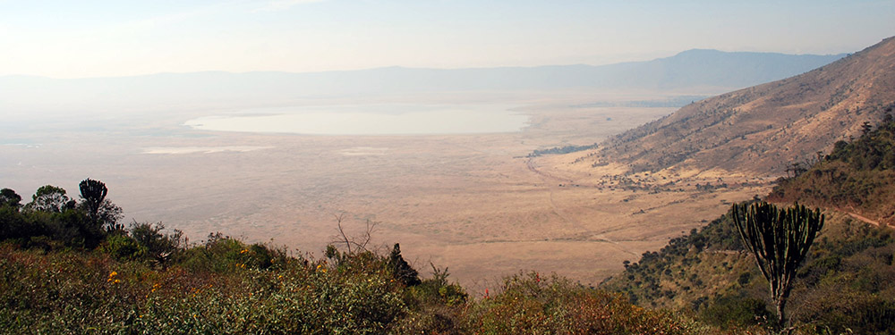
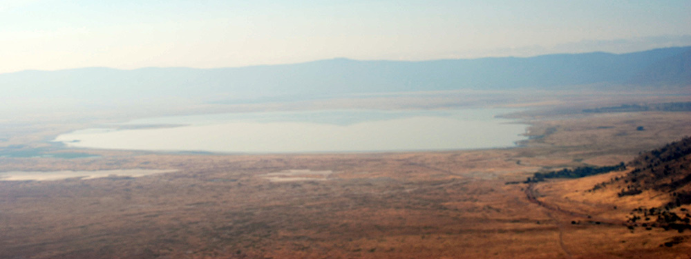
This protected area is named after the Ngorongoro Crater, the largest unbroken and unfilled volcanic caldera in the world, which is 610 meters deep and is home to over 25,000 large animals including some of the last remaining black rhinos in Africa.
About Ngorongoro Conservation Area
- Size: 8,292 kmq; the crater is 260 kmq, 610 meters deep
- Location: Northern Tanzania
- Crater size: 260 sq. km of surface
- Crater diameter: 22.5 Km
Nearby Ngorongoro Conservation Area
- Lake Natron (North-East)
- Lake Eyasi (South-West)
- Lake Manyara National Park (South-East)
- Serengeti National Park (North-West)
- Arusha city (160 km)
- Kilimanjaro Mountain (300 km)
For more information and the map:
Ngorongoro Crater
Ngorongoro Crater is the largest volcanic caldera and the main attraction in Ngorongoro Conservation Area. Also referred to as the eighth wonder of the world, the crater is famous for the very high wildlife concentration that finds in this volcanic caldera an ideal habitat in all seasons.
The crater is part of the “Ngorongoro Conservation Area” reserve, which extends for about 8300 sq. km East of the Serengeti National Park and North-West of Arusha. Populated by over 25,000 mammals, it is also a paradise for birdwatchers.
During the game drive, you can spot many species including large predators such as lions and cheetahs, large mammals such as elephants, buffaloes, zebras, wildebeest, and, with a bit of luck, the very rare black rhino.
During the game drive you cross the plains, Lerai forest, Magadi lake and you can have lunch at "Toc-Toc" picnic area with big hippos close by.
Ngorongoro is not a national park but a reserve (UNESCO World Heritage Site) where the Maasai can live with their domestic animals together with wildlife. This is not possible in the national parks where human settlements and domestic animals are not allowed.
In addition to the famous Ngorongoro crater, the Olmoti and Empakai minor craters and the Olduvai Gorge, one of the most important archaeological sites in the world, are worth a visit.
The best time to visit Ngorongoro (weather)
The busiest period is the dry season, which runs from July to October when the animals are concentrated around the water points and the less dense vegetation allows easy spotting. Ngorongoro Conservation Area can be visited at any time during the year because even in the humid season the rains are not heavy and nature is wonderful.
If you wish to witness the Great Migration, the best time is from late December to early March when the herds move from Central Serengeti to South Serengeti and Ndutu Area in Ngorongoro.
Ngorongoro Safari
The game drive in Ngorongoro crater is an exciting day, you can see a lot of animals very close and enjoy the crater view.
You can also visit a Masai village to learn and experience Maasai culture and traditions.
All our safari programs include a visit to the Ngorongoro crater. The best-selling safaris to visit Ngorongoro are:
You can contact us for a tailor made safari program – info@savannahexplorers.com – Whatsapp +255 765 972 458
Ngorongoro Lodges and Camps
At Ngorongoro, it is recommended to stay overnight in a lodge in the village of Karatu, such as the Marera View Lodge, or inside the reserve in one of the crater-rim lodges with fantastic views of the crater. We recommend the Serena Ngorongoro, the Sopa Ngorongoro, or the luxurious Crater Lodge.
For the more adventurous it is possible to camp at the "Simba campsite" where however a certain spirit of adaptation is required.
Following the Great Migration in the Ndutu area we can stay overnight in the mobile tented camps, or at the Ndutu Safari Lodge or the Masek Tented Lodge.
Ngorongoro Conservation Area Wildlife
Ngorongoro crater wildlife concentration is unique in the world. The crater surroundings are covered by forest, while inside, bordered by a ridge about 600 meters high, various ecosystems have developed such as pastures, swamps or even forest and plains. In the middle of the crater there is the alkaline lake Makat, fed by the Munge River.
In the crater you can spot many animals such as zebras, elephants, wildebeest, buffaloes, Grant's and Thomson's gazelles, hippos, cheetahs, hyenas and even black-maned lions and leopards. We also point out the exceptional presence of a small population of black rhinos, rare animals in danger of extinction, which live and reproduce here.
Olduvai Gorge Visit: "Cradle of Humanity"
Olduvai Gorge, sometimes spelled Oldupai, is the East Africa's most famous archaeological site and has become a must-see for visitors heading from Ngorongoro to Serengeti. It is located about 40 km North-West of Ngorongoro Crater, a few kilometers from the main road leading to Serengeti.
The Olduvai Gorge stretches for about 50 km and is up to 90 meters deep. Excavations at the Gorge began more than a century ago, producing a wealth of archaeological and paleontological data for the study of some key phases of early human evolution.
The first European known to have seen Olduvai Gorge was a German butterfly collector, Professor Wilhelm Kattwinkle. In his 1911 notes, he described Olduvai as "the book of life" and brought a considerable number of fossils back to Berlin, including the teeth of an extinct three-toed horse known as the Hipparion. However, Olduvai was made famous by the excavations carried out in the middle of the last century by the paleontologist Louis Leakey and his wife, Mary Leakey.
Louis Leakey first visited Olduvai Gorge in 1931. He and Mary discovered Zinjanthropus Boisei in 1959, making it the oldest significantly intact hominid fossil in Olduvai Gorge. This skull and other archaeological rests from Olduvai Gorge are kept in Dar es Salaam National Museum.
Bones of hominids belonging to the Homo lineage which includes Homo Habilis, Homo Erectus and Homo Sapiens have also been found in Olduvai, as well as hundreds of other fossil bones and stone tools dating back millions of years, leading paleontologists to conclude that humans they evolved in Africa.
The Olduvai Gorge museum exhibits numerous fossils and stone tools of our hominid ancestors and skeletons of many extinct animals carved into the gorge. The museum was founded by Mary Leakey and is dedicated to appreciating and understanding Olduvai Gorge and Laetoli fossil sites.
Empakai Crater
The Empakaai crater has a diameter of about 8 km, and in the center there is a beautiful lake that occupies almost half of its surface. The lake attracts flamingos and other water birds and is surrounded by steep wooded walls at least 300m high.
Outside, the elevation of Empakaai on the W estern side is 3,200 m. above sea level and on the Eastern side 2,590 m. above sea level. Due to this altitude, Empakaai is almost always shrouded in mist and the lake has an emerald or deep blue color.
Visitors to Empakaai can walk to the rim to admire the fascinating scenery and then walk down into the crater accompanied by the ranger. From the rim, visitors can see Ol Donyo Lengai volcanic cone to the North-East and even the alkaline Lake Natron glistening in the distance.
A steep path descends from the rim to the bottom of the crater through the mountain forest which is home to birds and monkeys.
The descent to the bottom of the crater takes between 30 and 50 minutes and may take twice as long to ascend. Visitors descending to Empakaai must be accompanied by an armed ranger.
Olmoti Crater
The Olmoti crater is located North of the Ngorongoro crater and South of the Empakaai crater. The bottom of Olmoti is shallow and grassy, and is the source of the Munge River, which feeds the Ngorongoro crater.
While not as famous as Ngorongoro and Empakaai, Olmoti Crater is worth visiting when traveling north into the highlands.
From the edge of the crater we can descend into the Olmoti crater accompanied by the armed ranger. The highest point of Olmoti is 3,080 meters, the crater has a diameter of about 6.5 km. There is a short path leading to the Munge waterfall.
Ol Doinyo Lengai
Ol Doinyo Lengai is the sacred mountain of the Maasai warriors and is located in Northern Tanzania, just South of Lake Natron in the Rift Valley, in the heart of the Maasai land. Looking North from the summit crater, the hot and arid salt flats of Lake Natron stretch into the distance, while to the South we find Ngorongoro Conservation Area.
Mount Ol Doinyo Lengai is 878 m. high and has explosive eruptions every twenty to forty years. This is the only volcano in the world that erupts natrocarbonatite lava. Its lava has almost no silicon and its temperatures are not as high as those of other lavas, around 500-600 ° C. Natrocarbonatite lava appears as a fluid of black oil and turns white in contact with objects filled with moisture. This whitening occurs almost immediately when it rains.
Mount Ol Doinyo Lengai can be climbed to the summit and sometimes even to the crater with a night time trekking accompanied by a Maasai guides.